
Day 1, 8:00 AM: Right on time our guide, Haukur Snorrason, arrived at our hotel and soon we were heading west out of Reykjavik. Also with us was Hadda Gisladottir. She and Haukur are the joint owners/operators of Phototours and the Hrífunes Guest House where we would be spending the penultimate night of the trip.

Route on Day 1
In the months prior to our arrival, our email exchanges with Haukur provided a wealth of options for consideration. His extensive experience as an Icelandic photographer and guide helped us develop an ambitious plan. It included several well-known and frequently photographed locations, a generous number of lesser known spots that he suggested, and some built-in time to take advantage of a few unexpected opportunities that might arise. And now we were finally underway, eager to experience whatever lay ahead of us.

Overview of Hraunfossar
Within a few hours we were overlooking Hraunfossar (Lava Falls), a 900-meter wide lava field that originated long ago from a volcanic eruption beneath the Langjökull glacier. The 40-mile long field is porous, enabling glacial meltwater and rainwater to move through it until reaching the terminus at the Hvítá River where it emerges as countless waterfalls cascading into the river.
Next up, an arranged stop at a nearby working farm where we could fraternize with some of the famous Icelandic horses (For more on this delightful animal, check my 2015 post here.

With socialable and curious personalities, Icelandic horses love to engage visitors
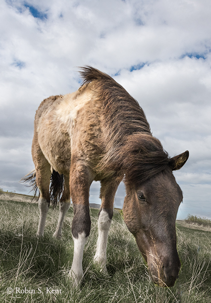
So friendly you need a super-wide (e.g., 14-24mm) to capture the entire animal.
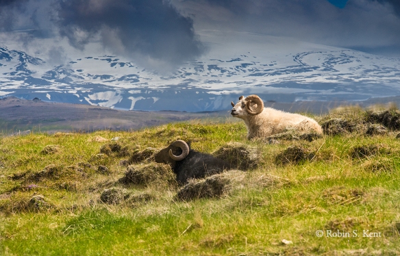
The sheep on this farm know where to position themselves for a picture
Iceland’s landscape is a magnet for tourists and has made the tourist industry an important economic sector. But the landscape also provides an even more significant economic benefit: renewable energy. One such source is geothermal energy and so we made a brief stop at Deildartunguhver, Europe’s most powerful hot spring. The water emerges at 207°F and is moved via pipelines to provide hot water and central heating for towns as far as 40 miles way. Overall, Iceland satisfies 87% of its demand for hot water and heat with geothermal energy, a key aspect of its energy strategy.

The Hot Water Pumping Station at Deildartunguhver
A hidden waterfall is always a special treat and our first one was a short hike from a highway in Snaefellsnes, a peninsula in Western Iceland. Other than a vague sign at the pull-over stop, there was no hint that this 30-foot cascade was less than 200 yards away. Perhaps six other people came by while we were there.
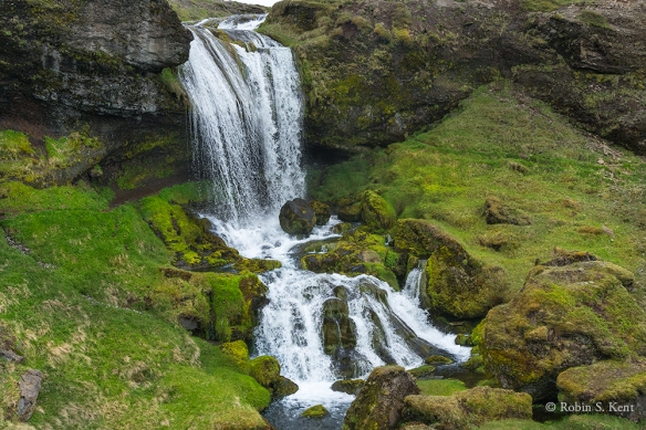
Roadside Waterfall (1/800th sec. @ f/10)

Detail of Cascade (0.4 sec @ f/16 with ND Filter)
The Kirkjufellfoss waterfall, however, with Kirkjufell Mountain as a dramatic backdrop, is one of the country’s major attractions and a good number of people were here when we arrived. Still, with careful timing, a bit of patience, and use of the photomerge technique, one can get an image containing no tourists.

Kirkjufellfoss waterfall
(Two images photomerged; 24 mm lens, 0.8 sec. @ f/20 with ND Filter)

Lupines bloom in June, usually peaking around the 2nd and 3rd weeks of the month and are a common sight at this time of year. This field was well off in the distance and probably would have been unnoticed by most travelers. But Haukur suggested we take a detour off the main highway onto a dirt road to check it out.

Icelandic Horses, Afternoon Light
Another unexpected opportunity appeared about 40 minutes after the field of lupines, so we stopped again, grabbed our telephotos, and fired away. And again, this was a scene we had to ourselves.
After checking into the Gauksmyri hotel, we departed immediately for another well-known location, the site of Hvitsekur Troll Rock, a sea stack just off the shore of Vatnsnes peninsula. We arrived at the perfect time; it was low tide and the sun was about to set. On the downside, it was quite cold (around freezing) and very windy. But perhaps because of those factors, along with the late hour (about 11:00 PM), only a couple of other people ventured down to the beach.

Hvitsekur Troll Rock at Sunset
Next: Across the Northern Tier……..

I was there last year, loved it and can’t wait to go back. Nice shots.
LikeLike
Thanks very much for the comments. Yes, the three of us have discussed another trip as well.
LikeLiked by 3 people
Such stunning scenery! The waterfalls are spectacular and I love troll rock. Really interesting post Robin.
LikeLiked by 1 person
Thanks, Chris. Yes, if you like waterfalls, Iceland is the place to go.
LikeLike
Love the post and the images!! Michele
LikeLiked by 1 person
Thanks, Michele. And thanks for letting me include the picture of you and the horse.
LikeLike
Gorgeous post! I visited Iceland as a tourist last year, and quickly fell in love. Happy memories! 🙂
LikeLiked by 1 person
Thanks very much. Yes, it’s a great place to visit.
LikeLiked by 1 person
What a beautiful and amazing place. With a local guide, I’m sure you got to see places no one else bothers to venture. Love the horses, but the waterfalls have me longer to go there!
LikeLiked by 1 person
Thanks! No worries on the waterfalls, plenty more coming. And yes, having Haukur as our guide meant we were getting to places we never would have found. He also happens to be a pilot and frequently flies over the island looking for potential locations. An upcoming post will give an example of one of those finds.
LikeLiked by 1 person
Wonderful photos.
LikeLike
Thanks for visiting! Glad to hear you liked them.
LikeLike
Love how detailed your blog posts are. We’re headed to Iceland later this summer and this is super helpful!
LikeLiked by 1 person
Thanks very much! I hope you have a great trip. And if you have any questions about our experiences, feel free to ask via the comments.
LikeLike
I love that you included a map showing your route. Your photos are amazing. I can’t wait to go.
LikeLiked by 1 person
Pingback: Where should I travel to in 2018? | Enjoying my journey....
Thanks for commenting on the post and for the kind words. Hope you have a great trip there.
LikeLike
Beautiful pictures! Cannot wait to see more of your road trip!!
LikeLiked by 1 person
Hi, good to see you again! I have been lax in keeping up with others but remembered that you had some great posts on your visit(s) to Iceland and that was the reason for reconnecting today. Hope to get the next post out soon.
LikeLiked by 1 person
Yes, I love Iceland. I’m off there in a few days 🙂 To get married this time!
LikeLiked by 1 person
Wow! All the best to you! What an exciting place to get married.
LikeLike
These photos are beautiful, Robin.
Just. Beautiful.
Hoping you’re well.
Best,
Dani
LikeLiked by 1 person
Thanks, Dani. Good to hear from you. Your recent post was as eloquent as ever. Take good care and I hope to hear from you again in the near future
LikeLiked by 1 person
Fabulous read! Iceland is definitely on my list now. Amazing snaps as well, keep up the great work. 🙂
LikeLike
Thanks very much for thye coments. I’m glad you liked the post and I hope you are able to get there soon.
LikeLike
What beautiful pictures, and thanks for sharing your trip. I enjoyed seeing your new work of art. You just keep getting better and better !! Have fun, keep well and say hi to Lori.
LikeLike
Hey, Grayce: Good to hear from you. And thanks for the kind words!
LikeLike