The Lake Myvatn Region derives its name from the large lake of that name and is characterized by a violent landscape created by numerous volcanic eruptions over the past 3,000 years. We were reminded throughout the day that there still is considerable power and heat below the surface on which we walked.
On this morning, we awakened to find that the snow had continued overnight long enough to change the character of the scenery. It was hard to believe this was early June.
 Volcanic Crater, Early Morning after a Snowfall
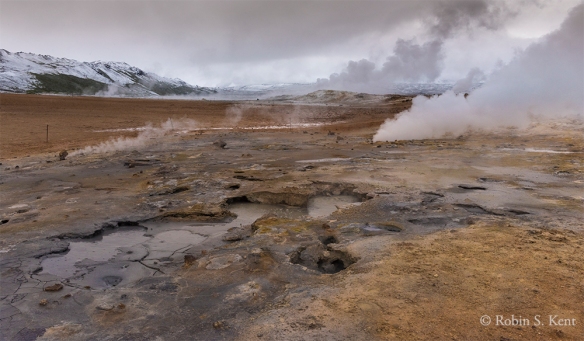
Namafjall Geothermal Field
An early start enabled us to arrive at the popular Namafjall geothermal field before the crowds and we had the place to ourselves. It reminds one of Yellowstone with the many mud pots, fumaroles, and venting hydrogen sulfide gas.
 Namafjall Geothermal Field
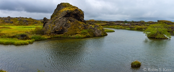 Unnamed Lagoon, Somewhere on Highway 1, Lake Myvatn Region
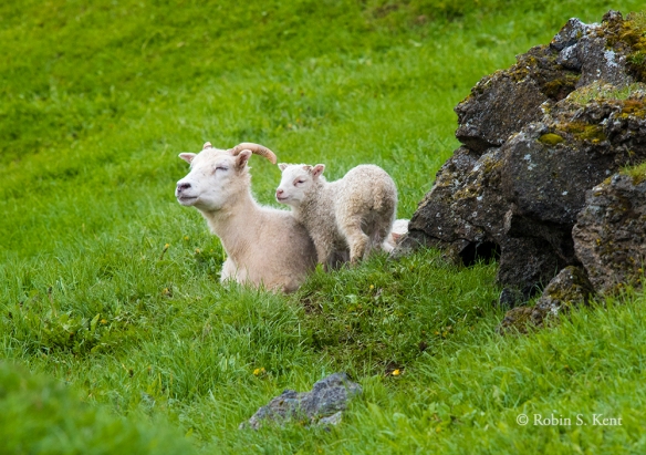 Lamb with its Mother, Somewhere on Highway 1, Lake Myvatn Region
 Snow on Mountains, Somewhere on Highway 1, Lake Myvatn Region
As we drove we west on Highway 1, we were repeatedly confronted with scenic opportunities and they were coming so fast that we failed to record the locations of the above three images.
The afternoon was spent hiking around the Leirhnjukur area, a name which means “clay hill” and refers to a porous hill of rhyolite rising 150 feet above a surrounding lava field. Steam is venting through the rhyolite and in some places it has turned to clay. The hike takes one up the hill, through some rugged lava formations, thermal pools, and numerous steam vents. One can’t help remembering that Kafla, a nearby volcano responsible for much of what we were seeing, last erupted in 1984 which really wasn’t that long ago.
 Leirhnjukur, View from the Trail (note hikers on top of the hill)
 View from the Overlook, Leirhnjukur (Trail is along near edge of black lava field)
 View from Leirhnjukur (Taken just before we began the descent back down to the car)
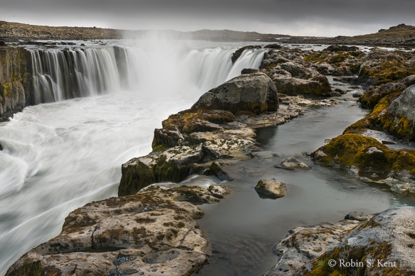
The name Dettifoss could be loosely translated as ‘The Collapsing Waterfall’. Considered to be the most powerful waterfall in Europe, it plummets into a gorge which is 330 feet across and about 144 feet straight down. The water comes from the nearby Vatnajökull glacier, the largest glacier in Europe, whose sediment-rich runoff colors the water a greyish white.
 Dettifoss, View from East Side
(For scale, note small black hiker at edge of falls on opposite side)
 Dettifoss, View from East Side (Taken from the edge of cliff about 50 feet above the river)
Selfoss, a smaller waterfall is an easy 1-mile hike upstream from Dettifoss. Not as high, but its horseshoe shape is rather elegant. When the water is running higher than when we were there, it would have been even more impressive with numerous cascades falling off the edges of the canyon walls for several hundred meters on both sides.
 Selfoss, View from East Side
(The pools of standing water in the foreground are often part of the cascade)
Next….the Famous “Ice Beach”

so many years since i was there
LikeLiked by 1 person
Thanks for visiting my blog and for the comments. I’m sure a lot has changed since you were there. Especially in Reykjavik.
LikeLiked by 2 people
So spectacular Robin! I can see why this is such a popular destination. Keep these posts coming!
LikeLiked by 1 person
Thanks, Chris! Much appreciated. More to come, for sure. By the way, great shot of the sv/TakeitEasy in Melbourne Harbor.
LikeLiked by 1 person
Thanks Robin😍
LikeLiked by 1 person
Superb.
LikeLiked by 1 person
Thanks, Sherry!
LikeLike
Robin, these are excellent and increased my already present desire to visit Norway.
Sharing with a friend …
LikeLiked by 1 person
Thanks for visiting and for the comments. I can understand why you are thinking of Norway; although I’ve not been there yet, the images I’ve seen from others indicate it is a spectacular place, especially in the Arctic North.
LikeLike
And of course I meant to type Iceland, not Norway 🙂
I want to visit both places!
LikeLiked by 1 person
No problem, typos hpapen! Can’t go wrong with either place.
LikeLiked by 1 person
The drama of Icelandic landscapes! So glad you were able to visit so many different parts of Iceland, Robin. Beautifully captured.
LikeLiked by 2 people
Thanks very much! Great to hear from you.
LikeLiked by 1 person
I’ll bet it was hard to tear the lens away and keep moving. I probably would have grown roots. Stunning!
LikeLiked by 2 people
Thanks! Yes, you’re right. Fortunately, Haukur, our guide would remind us gently when we tarried a bit too long. But he built in sufficient flexibility so we usually had time to assess a scene and get our shots. It helps when the days are 20 hours long.
LikeLiked by 1 person
so cool! from fields and craters to a lava field to lamb with momma – 🙂
LikeLiked by 1 person
Thanks! I’m glad you enjoyed the post.
LikeLike