Note: Special thanks to my photographer friend Kim, who introduced me to, and guided me through, this special place.
The Eastern Shore of Virginia is a 70-mile tract of land on the Delmarva Peninsula enclosed by the Atlantic Ocean on the east and the Chesapeake Bay on the west. Its northern border with Maryland and Delaware separates it completely from the rest of Virginia. On the Atlantic side, a series of barrier islands forms the longest remaining natural coastline along the entire eastern seaboard.

Sunset overlooking the Chesapeake Bay, Cape Charles, Virginia
Although this region is one of the earliest colonized areas of North America, Native American tribes flourished here long before European settlers first arrived at the beginning of the 17th Century. Characterized by fertile, easily tilled land and surrounded by the bay and ocean waters, the area remained a seafood and agricultural region with scattered small towns for almost 300 years.

Pear Valley 18th Century home, National Historic Landmark
(This tiny, frame house outside Eastville, VA has one room downstairs and two partial rooms in a sort of attic. It is an example of a middle class home in 1740)
In 1883, a group of railroad investors hatched the idea of a rail-sea link that would extend the terminus of the existing rail line in Maryland 65 miles down the peninsula to a massive pier where the rail cars would be loaded onto special barges that would carry them across the 36-mile stretch of water to a terminus in Norfolk.
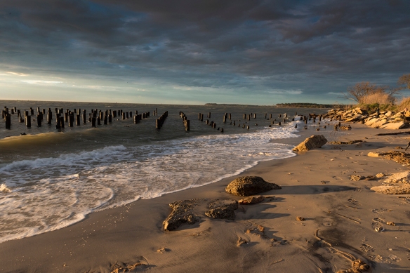
Sunset Old Ferry Pier, Cape Charles, Virginia
The creation of the new rail-sea line was the reason for the creation of Cape Charles which, from its very conception, was a planned community and its original layout is still visible today. Many of the original homes still stand, a diverse range of styles including Victorian, Colonial Revival, and even some of the Sears and Roebucks houses that were delivered as a “kit” of 30,000 pieces and a 75- page manual.

Intersection of Mason and Pine Streets (looking left)
The above image shows a former bank, dating from the early 20th Century, that has been renovated and is now a popular Irish pub.

Intersection of Mason and Pine Streets (looking right)
The above image shows a former bank, dating from the early 20th Century, that became a branch of the Bank of America and is now the town library.
With daily trains arriving from New York, the town quickly became the economic center of the lower peninsula. Benefitting from a planned system of paved streets, electricity, telephones, and central water and sewage systems, it was more cosmopolitan than the other shore towns. But the glory years began a downturn with the Great Depression in the 1930s, the decline of the railroads after World War II, and the opening of the Bay-Bridge tunnel in 1964.

The At Altitude Gallery, opened in 2015 by photographer Gordon Campbell in the renovated Wilson’s Department store and exhibiting his dramatic aerial photography of the Cape Charles area.
But, after several decades of continued economic and population decline, the trend has reversed. As indicated in the above image, new businesses have opened and its potential for tourism has been recognized. As indicated in my images below, photographers are particularly smitten with its natural beauty and diversity of subject matter.

Sunrise at Oyster
(Oyster is small unincorporated community, named for its fishing industry, located about 5 miles from Cape Charles on the opposite side of the peninsula.)

Osprey Nest at Sunrise, Cape Charles, Virginia

Sand Dunes off Bay Avenue, Cape Charles, Virginia

Kite Surfers, Cape Charles, Virginia

Eyre Hall Gardens, Cape Charles, Virginia
(Eyre descendents have owned land in the lower portion of Northampton County continuously since 1622 for 12 generations. The gardens, while privately owned are open to the public and are among the oldest gardens in the United States)

It seems to be a very photogenic region! Thanks for the interesting post, Robin!
LikeLiked by 1 person
Thanks, Chris. I’m sure you would like it, plenty of sailing space and that Osprey nest was about 50 feet from a 40-foot saiboat overnighting at one of the local marinas.
LikeLiked by 1 person
Such a wonderful spot, thanks for sharing
LikeLiked by 1 person
Thanks, Julz! I apolgize for being so slow in getting back to you, but things have been crazy around here. Nevertheless, I really apprecaiet your taking the time to comment and I hope to see you back here soon.
LikeLiked by 1 person
Thanks Robin….life gets busy 😀
LikeLiked by 1 person
What a lovely place to visit. Kim certainly steered you in the right direction! Hard to imagine a piece of property being owned by one family for 12 generations!
LikeLiked by 1 person
Thanks very much. Yes, that was prety impressive. Their gardens, which are open to the public, are essentially in their backyard. Very kind of them to do that.
LikeLiked by 1 person
Your photos are glorious as ever and – combined with your words – make me want to explore this area.
LikeLiked by 1 person
Thjanks, Laura. Great to hear from you and I’m glad you liked the post & pictures. Yes, this was a place I had no idea existed until my colleague started telling me about it. She wrangled an invite for me and another local photographer to join a group of shooters who convene there every year for a weekend photographing the locale.
LikeLiked by 1 person
Great Work, Really the pictures are so good to watch. I appreciate your hard work and efforts. It Really Inspired me and how it would be if we could connect and work. Let’s Contribute to community of Photographers. Have a look on my work at http://www.nitinkhanna.net/ and Let me Know how is it and Really would love to hear from Photographer like you. Thank You
LikeLiked by 1 person
Thanks very much for you comments; I really appreciate your very kind words. Apologies for being slow in responding. I was on a quick trip to NY City, returning just in time for the March for Science (new post on that coming soon). I checked your site and was quite impressed. You have a lot going o there and it looks very ineteresting.
LikeLike
What a magical meeting of land and sea that first image is, Robin. 🙂
LikeLiked by 1 person
Thanks so much. It was a great experience, but the conditions were tough: High winds, blowing sand, unpredictable clouds. But sometimes that is what can be a great opportunity when all of that power is accompanied by magical light.
LikeLiked by 1 person
And an intrepid photographer 🙂 🙂
LikeLiked by 1 person
Lovely photos, Robin! Hubby and I are very fond of the VA eastern shore, including Cape Charles. It’s like being in a different world. We’ve even talked of relocating somewhere along that peninsula. 🙂
LikeLiked by 1 person
Thanks, Donna. It’s a very cool place, and I can see why you have considered it, especially given the photo ops you would have. It’s starting to be discovered, however, so don’t wait too long; 🙂
LikeLiked by 1 person
Such a wonderful photo series! I really like the old Pear Valley home, rustic beauty:)
LikeLike
Thanks very much. Thanks for visiting my blog and I hope you will drop by again.
LikeLiked by 1 person
Great post Robin … I have been to this area and your images represent it beautifully. My favorite in the B&W sand dunes.
LikeLiked by 1 person
Thanks, Denise. I appreciate your thoughts. As you know from having been there, it’s still pretty much undiscovered which makes it special.
LikeLike