Hidden Gems: Cape Charles, Virginia


Note:  Special thanks to my photographer friend Kim, who introduced me to, and guided me through, this special place.

The Eastern Shore of Virginia is a 70-mile tract of land on the Delmarva Peninsula enclosed by the Atlantic Ocean on the east and the Chesapeake Bay on the west.  Its northern border with Maryland and Delaware separates it completely from the rest of Virginia.  On the Atlantic side, a series of barrier islands forms the longest remaining natural coastline along the entire eastern seaboard.

Cape Charles 04 Sunset

Sunset overlooking the Chesapeake Bay, Cape Charles, Virginia

Although this region is one of the earliest colonized areas of North America, Native American tribes flourished here long before European settlers first arrived at the beginning of the 17th Century.  Characterized by fertile, easily tilled land and surrounded by the bay and ocean  waters, the area remained a seafood and agricultural region with scattered small towns for almost 300 years.

Cape Charles 03 Pearl Valley

Pear Valley 18th Century home, National Historic Landmark

(This tiny, frame house outside Eastville, VA has one room downstairs and two partial rooms in a sort of attic. It is an example of a middle class home in 1740)

In 1883, a group of railroad investors hatched the idea of a rail-sea link that would extend the terminus of the existing rail line in Maryland 65 miles down the peninsula to a massive pier where the rail cars would be loaded onto special barges that would carry them across the 36-mile stretch of water to a terminus in Norfolk.
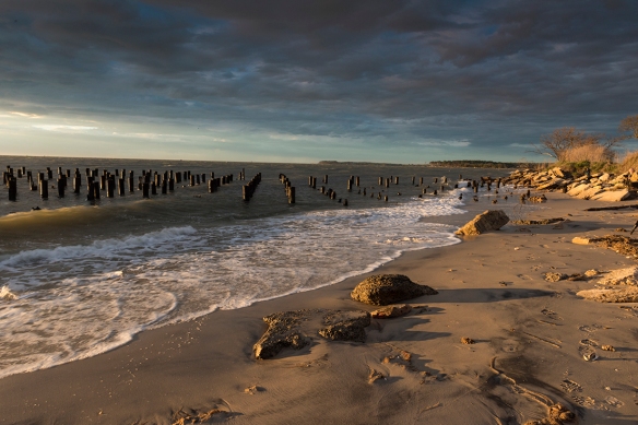
Cape Charles 11 Old FerryPier

Sunset Old Ferry Pier, Cape Charles, Virginia

The creation of the new rail-sea line was the reason for the creation of Cape Charles which, from its very conception, was a planned community and its original layout is still visible today.  Many of the original  homes still stand, a diverse range of styles including Victorian, Colonial Revival, and even some of the Sears and Roebucks houses that were delivered as a “kit” of 30,000 pieces and a 75- page manual.

Cape Charles 02 Kellys Pub

Intersection of Mason and Pine Streets (looking left)

The above image shows a former bank, dating from the early 20th Century, that has been renovated and is now a popular Irish pub.

CapeCharles 03A Libray

Intersection of Mason and Pine Streets (looking right)

The above image shows a former bank, dating from the early 20th Century, that became a branch of the Bank of America and is now the town library.

With daily trains arriving from New York, the town quickly became the economic center of the  lower peninsula.  Benefitting from a planned system of paved streets, electricity, telephones, and central water and sewage systems, it was more cosmopolitan than the other shore towns.  But the glory years began a downturn with the Great Depression in the 1930s, the decline of the railroads after World War II, and the opening of the Bay-Bridge tunnel in 1964.

Cape Charles 05 AT Altitude Galley

The At Altitude Gallery, opened in 2015 by photographer Gordon Campbell in the renovated Wilson’s Department store and exhibiting his dramatic aerial photography of the Cape Charles area. 

But, after several decades of continued economic and population decline, the trend has reversed.  As indicated in the above image, new businesses have opened and its potential for tourism has been recognized.  As indicated in my images below, photographers are particularly smitten with its natural beauty and diversity of subject matter.

Cape Charles 08 Oyster Sunrise

Sunrise at Oyster

(Oyster is small unincorporated community, named for its fishing industry, located about 5 miles from Cape Charles on the opposite side of the peninsula.)

Cape Charles 01 Osprey

Osprey Nest at Sunrise, Cape Charles, Virginia

Cape Charles 09

Sand Dunes off Bay Avenue, Cape Charles, Virginia

Cape Charles 10 (Kite Surfers)

Kite Surfers, Cape Charles, Virginia

Cape Charles 07 Eyre Gardens

Eyre Hall Gardens, Cape Charles, Virginia

(Eyre descendents have owned land in the lower portion of Northampton County continuously since 1622 for 12 generations. The gardens, while privately owned are open to the public and are among the oldest gardens in the United States)

Sleeping Beauty

There is one building on the National Mall that has been closed to the public for a decade but, thanks to a renovation project launched in 2009, is now beginning to awaken.  It is the Arts and Industries Building next (east side) to the Smithsonian Castle.

Sleeping Beauty 10

Arts and Industries Building, View from the Enid Haupt Garden at the Smithsonian Castle

Background

It’s a large building (the roof covers 2.5 acres) and it has been here a long time.  Constructed in 1879-1881, it was the first building created solely to house the US National Museum. The National Museum’s collections had been housed in the Smithsonian Castle since the 1850s but soon outgrew the space.   Spencer Baird, Secretary of the Smithsonian at the time, devoted his entire career to developing a great National Museum at the Smithsonian and this building brought his dreams to reality. A detailed history of the building can be found here.

The structure was renovated in the 1970s for a special exhibition during the National Bicentennial celebrations in 1976.  Afterwards, it was used for a variety of temporary exhibits but its condition slowly deteriorated until it received the dubious distinction in 2006 of being named as one of America’s Most Endangered Places by the National Trust for Historic Preservation and was closed soon afterwards.  Three years later, some of the funding needed for its restoration was made available by the American Recovery and Reinvestment Act.  Although the funding  was only about 30-40% of the total amount required, it was sufficient for a “shell restoration,” essentially restoring the exterior face, replacing the roof and windows (all 911), and stabilizing the structure.

Arts and Industries building

Undergoing rennovation


The above image is by G. Edward Johnson, courtesy Wikipedia and the source information can be found here.

When the exterior scaffolding was removed at the end of this phase, the results were quite impressive.

Sleeping Beauty 09

Detail of Jefferson Street Entrance

Sleeping Beauty 14

Exterior of the Central Rotunda, View from Independence Avenue

Sleeping Beauty 13

Western Facade, View from across Independence Avenue

But funds are not available (so far) for an equivalent restoration of the interior and it is not open for the public.  However, the Smithsonian Associates recently held a special “open house” and I joined several hundred others to get a rare look at the interior.

Sleeping Beauty 07

South Hall Looking Toward Independence Avenue

It was a festive event, with games, music, and food.  There was much interest in the presentations, especially the compelling  story of the restoration project as related by Construction Manager Pat Ponton (above).   Built in a time without air conditioning and before electrical lighting was practical,  the visionary design incorporated natural light and circulation, high ceilings and fireproof materials that foreshadowed modern construction techniques.

Sleeping Beauty 05

Games for the Visitors

The black marble used in the geometric floors was quarried in Vermont and is characterized by a variety of fossils dating back 480 million years.  The same marble was also used in Radio City Music Hall in New York City.

Much work remains but one can glimpse its former glory, especially when looking up at the dome above the central Rotunda.

Sleeping Beauty 01

Dome over the Rotunda

According to Frederica Adelman, the Director of the Smithsonian Associates, the space is being made available for rent for private functions.  But lacking sufficient funding for the full restoration, final plans for the building’s ultimate purpose have not been made.

Tours are periodically offered by the Smithsonian Associates, so stay alert for future opportunities to get a peek.  In the meantime,


Keep Shooting….


Hidden Gem: Mexico’s Monarch Preserves

Well, the Google Doodle beat me to the punch yesterday, marking the 41st anniversary of the discovery of the overwintering site of the Monarch butterfly.  But that’s OK, I’m going ahead with this anyway.

D-11-01-18-0271 (Keynote)Monarchs Overwintering in Mexico (2011)

By the mid-20th century the existence of the monarch migration had been well known for many years, but not its full route.  Every August and September, millions of monarchs in the eastern United States and Canada would start flying south toward Mexico and disappear.   Then, around March, they would reappear on a northward journey. The location where they spent those intervening months was unknown.  It was one of nature’s great mysteries.

Until January 9, 1975.

Monarch 05 D-11-01-20-0501

In that year, a group of scientists following clues left by tagged butterflies that had fallen on the journey south were led to a place high in the mountains of Mexico’s eastern Sierra Madre Mountains. There they found millions of butterflies clinging to the branches of the oyamel trees that grow at altitudes as high as 11,000-12,000 feet.

Monarch 06 D-11-01-18-229_233 PAN

The fact that these small creatures can actually make the trip of several thousand miles is not the most amazing part of the story.  What is most incredible is that none of them had ever been there before. Yet each year a new torrent of monarchs, separated by three or four generations from those that flew there the previous year, finds its way to those same oyamel trees.

I became entranced with this story in 2001, after reading “Four Wings and a Prayer” by Sue Halpern who traveled to Mexico in a truck with legendary monarch tracker Bill Calvert and experienced first-hand the spectacle of the monarch migration.

Monarch 09 D-11-01-18-237_238 PAN

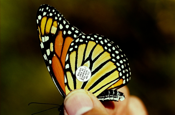
My own journey started shortly afterwards with a trip to Cape May, New Jersey,  a key crossing point for the southbound monarchs over Delaware Bay.  Butterfly researchers at the Cape May Bird Observatory demonstrated the technique of tagging the monarchs and how the tracking depends on anonymous individuals who find a tagged butterfly and report the information of where and when to research centers.

Monarch 01 1602-21

Tagged Monarch Before Release (2001)

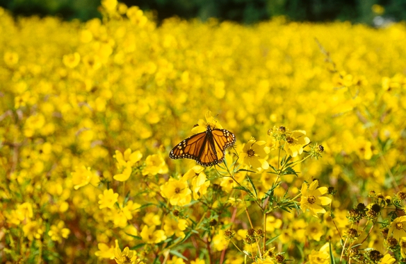
A few days later, I caught up with a researcher in Lorton, Virginia who was tagging southbound monarchs in a field of yellow wildflowers (image below).   He had almost

Monarch 02 1602-33

Migrating Monarch, Lorton VA (2001)

reached his annual goal of 500 taggings, but was despondent over the fact that this waystation for the monarchs was about to become a shopping center.

Monarch 08 1602-32

Lorton, Virginia (2001)

Seven years later, I was at Pictured Rocks National Lakeshore, on the south shore of Lake Superior, when I spotted a few flashes of orange.  It was a pair of migrating monarchs just arriving from their 100-mile-plus flight across the great lake from Canada.  They still were over 2,500 miles from their destination.

Monarch

Migrating Monarch, Pictured Rocks National Lakeshore, MI (2008)

In the fall of 2010, a friend called asking if I would like to join her on a trip to see the overwintering sites in Mexico. My answer was quick and the following January, we found ourselves on a long bus ride from Mexico City to the mountain village of Angangueo. But this was just the first of many transportation modes we would use in the coming days such as the back of pick-up trucks, riding horses, and finally hiking on our own at lung-busting (to us at least) altitudes of 11,000 feet and higher.

Monarch 03 D-11-01-18-0508

Getting Closer, but a Tough Hike Awaits (2011)

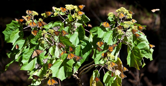
But it was all worth it.  Photographs really can’t communicate the scale of the scenes we witnessed.  There are so many butterflies clustered on the trees that the branches bend downward from the weight, occasionally even breaking.The image below shows a small section of a stand of trees in one of the preserves.  Imagine that no matter where you look from this position, all the trees surrounding you are covered from top to bottom with what seem like orange leaves but really are butterflies.

Monarch 11 D-11-01-17-0139

Monarch Clusters on Oyamel Trees, Mexico (2011)

Mexico does try to protect the sanctuaries, although illegal logging is one of many serious threats.  But on the positive side they enforce strict (5 mph) speed limits on a highway that occasionally is also used by the monarchs when searching for water outside the preserves.

Monarch 10 D-11-01-20-0539

Monarch Crossing, Mexico  (2011)

An equally serious threat is the loss of habitat in the United States.  Remember that shopping center in Lorton, Virginia? There has been a steady decline in the numbers of monarchs reaching the preserves over the past decade, but there was a slight uptick last

Monarch 13

Chart of Monarch Counts in Mexico (1994-2014)

year.  Preliminary estimates for this winter are cautiously optimistic, with hopes that they might reach the levels of 2011, when I was there.  Keep your fingers crossed and….


Keep Shooting….

Hidden Gems:  Hartford’s Sculpture Walk at Riverfront

Tomorrow’s meeting wasn’t going to start until 9:30 AM and the hotel was a 2-minute walk from the Connecticut River.  A quick check of The Photographer’s Ephemeris app revealed there would be an opportunity for a sunrise illumination (at 7:05 AM) of the Hartford skyline across the river.  OK, set the alarm for 6:15 AM.

Arriving at the river’s edge the next mornioing about 20 minutes before sunrise, I had a few minutes to check things out and noticed a stairway leading up to Founders Bridge. At the top of the stairs,there was a magnificent pedestrian walkway, wide enough for a car and way better than anything we have in Washington.

Hartford D-15-12-04-0228

Founders Bridge, Hartford Connecticut

And it turned out this was no ordinary promenade.  It was part of the Lincoln Sculpture Walk that follows a course through two riverside parks, one on each side of the river.  Made possible by a $500,000 donation from the Lincoln Financial Group, a local firm, it features 15 permanent sculptures dedicated to the life and times of Abraham Lincoln. Those who know my photography know that the Lincoln Memorial is one of my favorite subjects.

Hartford D-15-12-04-0224

“Emancipation,” by Preston Jackson

This sculpture, “Emancipation,” was fortuitously (for me) placed right a few steps from the stairway landing.  It is one of two works in the Sculpture Walk by Preston Jackson, a prominent African American artist from the Art Institute of Chicago.  It depicts a female slave carrying her infant and a few possessions toward freedom.  The soft illumination of the twilight minutes before the sunrise seemed to underscore the power of the work.

As the sun edged above the horizon, the colors began to illuminate the city’s skyline.  The image below was captured one minute after sunrise.

Hartford D-15-12-04-0238

Sunrise View of Hartford from Founders Bridge

But I could see that there were might be more potential down below along the river’s edge and I retreated down the stairway and found a good spot to wait. My luck continued as a series of clouds continued moving in from the west and the light breeze began to subside.  And sure enough, about 15 minutes later, the golden light reached its peak.

Hartford D-15-12-04-0266_68-RAW Pano

As I walked back to the hotel, it seemed that going out for a morning walk was a lot better than sleeping in.


Keep Shooting…..


Hidden Gems: The Christmas Angel

Knowing where to be and when to be there is often the key to a special image.  Most of the time the “when” is hard to know in advance.  But one opportunity that occurs like clockwork every year is the phenomenon known as “The Christmas Angel” at the National Cathedral in Washington, DC.

At the back of the Cathedral (opposite end from the entrance, known as the apse), high on a wall, there is a row of statues of angels spaced at regular intervals.  The statues are not particularly remarkable because they are in the shadows and one would not normally notice them.  But there is one statue that becomes a major attraction for a few minutes each day in the months of November and December.  A stained glass window high on the opposite wall is perfectly located to allow a shaft of light strike the back wall of the nave at midmorning.

Natl Cathedral D-15-11-20-0047

Photographed at 10:41 AM

The image above shows the light striking the wall to the (photographer’s) left of the statue, which is hardly visible.

Natl Cathedral D-15-11-20-085 ver 01

Photographed at 11:21 AM

Thirty minutes later, the light has moved to the right and begins to illuminate the statue.  By 11:20 AM the statue is fully illuminated and will remain that way for about five minutes.

Natl CathedralD-11-15-20-086

Close-up photographed at 11:22 AM

After a few minutes the light begins to disappear as the sun moves out of position.  See the image below.

Natl Cathedral D-15-11-20-097

Photographed at 11:43 AM

By 11:40 AM, the light was essentially gone.

Keep shooting….

Virginia Road Trip: Buzzard Rock and Thoroughfare Gap

Memorial Day weekend is great time to be in Washington DC—if you are a fan of motorcycles, parades, and ceremonies.  We decided to go the other direction on Sunday, heading west toward Front Royal and the George Washington National Forest.

We had heard about an “easy hike” near Front Royal, called “Buzzard Rock” that features a nice overlook of the Shenandoah Valley.  Not nearly as well-known as more popular hikes such as Old Rag, White Oak Canyon, or Dark Hollow Falls we guessed that it would not be very crowded.

Virginia 02

 Looking North from First Outlook

We arrived at the trailhead at 10:00 AM—later than advisable if you want to beat the crowds, but there were still a couple spots left in the small parking lot.  It’s a 4-mile roundtrip, with a gradual elevation gain of about 650 feet along a fairly well-marked trail.  It’s a pleasant walk up to the first overlook where one is rewarded with some nice scenery of the Valley below.  There is also a good view of a fish hatchery along Passage Creek (Image below).

Virginia 03

Fish Hatchery as seen from First Outlook

While the views at the top were nice, I would not place this trail on my top 10 list for Virginia hikes within a 2-hour drive of Washington.   But that’s OK, because the more interesting portion of the day was still ahead.

Our mission was to find the secret route to Chapman’s Mill, a massive historic stone structure that is in full view (about 100 yards away) of thousands of cars on Interstate 66.  My previous solo attempts had ended in failure, but now that I had the assistance of a skilled navigatrix and her wonder dog Smokey, I felt confident that success was finally within my grasp.

 Virginia 04The Ruins of Chapman’s Mill, (walls now stabilized and braced)

To give you a small sense of the challenge, Chapman’s Mill is located on Beverly Mill Road and once you drive past the mill on I-66 heading east, you must drive 8 more miles and then backtrack the same distance on State Road 55 to get there.

Virginia 05Partially collapsed Interior Wall (much work remains)

Chapman’s Mill was originally built in 1742 and, at 7 ½ stories, is thought to be the tallest stacked stone building in the United States.  The mill is located in Thoroughfare Gap, a narrow passage in the Bull Run Mountains.  The Gap was used by migrating buffalo and traveling American Indians long before Europeans arrived in the area.

Virginia 07

Detail of Wall, Showing Stacked Stone Technique

The gap quickly became a major route to the rich farmland of the Shenandoah Valley, was a strategic route in the French and Indian Wars, the Revolutionary War, and the Civil War and its importance as a trade route was enhanced with the arrival of a rail line (still operating today) in 1852.Virginia 06

Interior View, showing Rusting Cogwheel (about 6-foot diameter)

The mill was a major food storage and distribution center for the Confederate forces until mid-1862 and was burned by the Confederates when they departed the area.  Rebuilt after the war, it continued to operate as a mill, passing through several owners until it ceased operations in 1946.

Virginia 09

Interior View Showing a Stabilizing Cross Beam

Abandoned for years, it escaped demolition in the 1960s from the planned route for I-66 through the efforts of local citizens and preservation groups.  In 1998, it was torched by an arsonist. The devastation was so extensive that the building seemed doomed to extinction.  But shortly thereafter, a non-profit group obtained the property and launched a restoration campaign.  Phases 1 and 2 (Stabilizing the walls, conducting archaeological research on the site) are completed and fudraising is underway to continue the restoration.

 Virginia 08Smokey, the Wonder Dog, Contemplates the Scene


The mill is open to the public on Saturdays and Sundays.  Click here for more information.

New York City- Part 2

Spring is the best time to be in New York City.  Unfortunately, it is also the best time to be in many other places such as Washington, DC.  But when one has business in NYC in late April or early May, one must bring a camera.

The afternoon stroll through Central Park on our first day only whetted our appetite.  So it seemed that an evening visit to the top of Rockefeller Center would be a good way to end the evening.

NYC 01

Top of the Rock, looking south

(Technical: Nikon D800E, resting on balustrade, with 24-70 mm f/2.8 extended to 24 mm; Exposure: 0.6 sec. at f/16, ISO 800.)

NYC 02

 Setting sun, Top of the Rock, looking west

(Technical: Nikon D800E hand held, with 24-70 mm f2.8 extended to 42mm, Exposure 1/640th   sec. at f/10.0, ISO 800.)

The next day, we took the E Train to the World Trade Center to check out the progress on the new PATH Terminal designed by Santiago Calatrava and visit the 9/11 Memorial.  The last time I had been there was in May 2013, shortly after the Memorial had opened and security had been exceptionally strict.   They have relaxed a lot since then.  One can stroll right into the grounds.

NYC 04

View of one of the two reflecting pools, surrounded by waterfalls.

NYC 03

The names of the victims are inscribed in bronze around the twin pools.

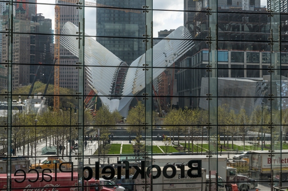
Brookfield Place, housing scads of places to eat and shop, is right across the street in Battery City Park.  We only had time for a quick peek, but I am definitely going back to explore Le District (billed as a French market) in detail. This place is gy-normous.

NYC 05

The Winter Garden Atrium looking out toward the Hudson River

New York 06

View from Brookfield Place looking toward the PATH Terminal under construction.

The new PATH Terminal is suffering a lot of ridicule in the New York media. But, having seen structures designed by this controversial architect in places such as Valencia, Barcelona, Milwaukee,  California, and Buenos Aires, I expect it will be impressive once it is finished (assuming the engineers can fashion his design into reality).

The next morning we headed over to the High Line, a 1.5-mile elevated train line that has been transformed into a highly popular aerial greenway.

NYC 06

Tracks from the former NY Central spur line are integrated into the design

NYC 07

If it’s New York City, there will be a fashion shoot

NYC 08

Hidden Gem: The High Line Hotel courtyard, just a block away from the actual High Line, is a great place for a coffee break.  Previously part of a seminary, it was once a large estate and apple orchard owned by the man who is thought to have authored “The Night Before Christmas.”

NYC 09

The High Line has numerous, and often amusing, public art installations

NYC 12

The new Whitney Museum is located at the southern terminus of the High Line

NYC 11

It was opening day and the line stretched for several blocks.

NYC 10

But the view up there is supposed to be great

Maybe on the next visit….

Keep shooting.

Cherry Blossoms–Not Yet!

Although the cherry blossoms have yet to  fully awaken, there are plenty of other photographic opportunities right now in Washington, DC.

At sunrise two days ago, the tidal basin was almost completely deserted.   The sky was clear which means you can get the shot below as the sun clears the horizon.

Jefferson Sunrise 02

Sunrise, April 2, 2015

At sunrise the  next day, rain clouds were coming in from the west but there were some openings in the eastern sky.  Again, the tidal basin was deserted.

Jefferson Sunrise

Sunrise, April 3, 2015

The rain started within an hour after the image above was taken but it was a light rain so I checked out the status of the pink magnolia trees in Rawlins Park (E Street, Foggy Bottom) that usually are open before the cherry blossoms.

Tulip Trees 01

Afternoon Rain Shower, Rawlins Park

Tulip Trees 02

Magnolia, Rawlins Square

Tulip Trees 03

Magnolia, Rawlins Square

While photographing the square, I noticed some white magnolias across the street at the Red Cross National Headquarters (20th and E Streets NW).  A quick check showed that an evening shot might be worthwhile.

Red Cross 01

Evening, Red Cross Headquarters

This morning, I checked out the Enid Haupt Garden at the Smithsonian Castle on Independence Avenue.

Tulip Trees 05

Morning, April 4, 2015

If you want to photograph these trees, don’t delay.  They go quickly and inclement weather is forecast for mid-week.You can also find them in the Sculpture Garden (National Gallery of Art) and at the George Mason Memorial near the Jefferson Memorial.