Martin Luther King

D-12-01-18-6556_61 (MLK Birthday)Sunrise, Martin Luther King Memorial

“I believe that unarmed truth and unconditional love will have the final word in reality. This is why right temporarily defeated is stronger than evil triumphant. I have the audacity to believe that peoples everywhere can have three meals a day for their bodies, education and culture for their minds, and dignity, equality and freedom for their spirits. I believe that what self-centered men have torn down, men other-centered can build up.”

Words excerpted from Martin Luther King’s speech accepting  his Nobel Peace Award,  Oslo Norway, December 10, 1964.


Hidden Gems: Cape Charles, Virginia


Note:  Special thanks to my photographer friend Kim, who introduced me to, and guided me through, this special place.

The Eastern Shore of Virginia is a 70-mile tract of land on the Delmarva Peninsula enclosed by the Atlantic Ocean on the east and the Chesapeake Bay on the west.  Its northern border with Maryland and Delaware separates it completely from the rest of Virginia.  On the Atlantic side, a series of barrier islands forms the longest remaining natural coastline along the entire eastern seaboard.

Cape Charles 04 Sunset

Sunset overlooking the Chesapeake Bay, Cape Charles, Virginia

Although this region is one of the earliest colonized areas of North America, Native American tribes flourished here long before European settlers first arrived at the beginning of the 17th Century.  Characterized by fertile, easily tilled land and surrounded by the bay and ocean  waters, the area remained a seafood and agricultural region with scattered small towns for almost 300 years.

Cape Charles 03 Pearl Valley

Pear Valley 18th Century home, National Historic Landmark

(This tiny, frame house outside Eastville, VA has one room downstairs and two partial rooms in a sort of attic. It is an example of a middle class home in 1740)

In 1883, a group of railroad investors hatched the idea of a rail-sea link that would extend the terminus of the existing rail line in Maryland 65 miles down the peninsula to a massive pier where the rail cars would be loaded onto special barges that would carry them across the 36-mile stretch of water to a terminus in Norfolk.

Cape Charles 11 Old FerryPier

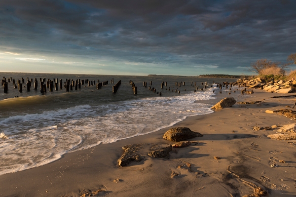
Sunset Old Ferry Pier, Cape Charles, Virginia

The creation of the new rail-sea line was the reason for the creation of Cape Charles which, from its very conception, was a planned community and its original layout is still visible today.  Many of the original  homes still stand, a diverse range of styles including Victorian, Colonial Revival, and even some of the Sears and Roebucks houses that were delivered as a “kit” of 30,000 pieces and a 75- page manual.

Cape Charles 02 Kellys Pub

Intersection of Mason and Pine Streets (looking left)

The above image shows a former bank, dating from the early 20th Century, that has been renovated and is now a popular Irish pub.

CapeCharles 03A Libray

Intersection of Mason and Pine Streets (looking right)

The above image shows a former bank, dating from the early 20th Century, that became a branch of the Bank of America and is now the town library.

With daily trains arriving from New York, the town quickly became the economic center of the  lower peninsula.  Benefitting from a planned system of paved streets, electricity, telephones, and central water and sewage systems, it was more cosmopolitan than the other shore towns.  But the glory years began a downturn with the Great Depression in the 1930s, the decline of the railroads after World War II, and the opening of the Bay-Bridge tunnel in 1964.

Cape Charles 05 AT Altitude Galley

The At Altitude Gallery, opened in 2015 by photographer Gordon Campbell in the renovated Wilson’s Department store and exhibiting his dramatic aerial photography of the Cape Charles area. 

But, after several decades of continued economic and population decline, the trend has reversed.  As indicated in the above image, new businesses have opened and its potential for tourism has been recognized.  As indicated in my images below, photographers are particularly smitten with its natural beauty and diversity of subject matter.

Cape Charles 08 Oyster Sunrise

Sunrise at Oyster

(Oyster is small unincorporated community, named for its fishing industry, located about 5 miles from Cape Charles on the opposite side of the peninsula.)

Cape Charles 01 Osprey

Osprey Nest at Sunrise, Cape Charles, Virginia

Cape Charles 09

Sand Dunes off Bay Avenue, Cape Charles, Virginia

Cape Charles 10 (Kite Surfers)

Kite Surfers, Cape Charles, Virginia

Cape Charles 07 Eyre Gardens

Eyre Hall Gardens, Cape Charles, Virginia

(Eyre descendents have owned land in the lower portion of Northampton County continuously since 1622 for 12 generations. The gardens, while privately owned are open to the public and are among the oldest gardens in the United States)

Galapagos Islands (Part 3)

The Galapagos Islands and Charles Darwin have been inextricably linked since the publication of his “Origin of the Species” 25 years after he visited the islands as a 22-year old geologist aboard HMS Beagle.  While Darwin is generally credited with conceiving the idea of evolution, the theory actually had its beginnings with a French naturalist, Jean Baptiste de Lamarck, who died in poverty and obscurity six years before Darwin arrived in the Galapagos Islands. Darwin’s contribution, however, was equally important.  He explained how and why evolution occurs.

So when you travel to the Galapagos Islands, an eerie feeling comes over you as you realize that the individual birds, mammals, and reptiles you are viewing and photographing most likely are direct descendants of the very creatures that inspired one of the most revolutionary scientific conclusions in history.

At the same time, this wildlife sparks a sense of wonder regardless of its ancestry.  And that is what the rest of this post will focus on.

Galapagos 29 3 Boobies

Blue-footed Boobies Conferring

Although I rated the Sally Lightfoot Crab as having the coolest name, my overall favorite should be no surprise;  it is the blue-footed booby.

Galapagos 30 Booby

Their ridiculously colored blue feet, serving as their namesake, ironically are contradicted by the steely gaze of their arresting eyes and the impeccable sleekness of their plumage.  When their stare fixes you, you become grateful that you are not a small fish.

But while humans may smirk at their garishly colored feet, the color blue is a very big deal to both the male and female booby.  The  males take great pride in their fabulous feet. During mating rituals, male birds show off their feet to prospective mates with a high-stepping strut. The bluer the feet, the more attractive the mate.  The short video clip below was filmed by our trip leader.

(Video by James Zimbelman, Smithsonian Institution)

Yet, when you watch the birds in their role as a predator, you realize why that piercing glare gave you pause.  Circling high above the ocean in search of anchovies and other small fish,   they will suddenly fold their long wings back around their streamlined bodies and plunge into the water at speeds up to 60 mph.  It happens so quickly that I failed in every attempt to capture that critical moment of hitting the water.  The best I could do was the shot below, when a successful plunge was followed by the bird as he/she was taking off.

Galapagos 10 Blue Footed Booby

Blue-footed Booby on Take-off Run

There are many ways to see the Galapagos Islands including larger ships (about 90 passengers), small charter vessels that may take as few as 12-16 passengers, or on-island lodging (ranging from regal to rustic).  Choosing the latter may restrict your ability to visit more than 1-2 islands unless you are willing to change lodging a few times.  The variety of wildlife you will see depends on which islands you choose to visit.  Not all itineraries are the same.  But however long you stay, you will be glad you made the journey.

Galapagos 26 (Straight Shot No Tricks)

  Frigatebird at Sunrise, Galapagos Islands

(Technical: Nikon D810 handheld with 24-70mm f/2.8 lens at 70mm; exposed @ 1/800th sec. @ f/16, ISD 400; No Photoshop trickery used in positioning the bird over the sun)


Galapagos Islands (Part 2)

Galapagos 20 Approaching Storm

Approaching Storm at Sunset

(Techniical Stuff: Nikon D810 handheld on moving ship with 70-200mm f/2.8 lens extended to 150mm; exposure 1/250th sec. @ f/14, ISO 800; four images photomerged)

The volcanic archipelago making up the Galapagos Islands is relatively young by geological measures and on some of the newer islands you may see only the initial stages of plant life.

Galapagos 12 Cactus

A Cactus Plant Finds a Spot on a Lava Formation

One of the strange aspects of volcanic activity is the formation of lava tubes.  Don’t ask me for an understandable explanation, but it has to do with the lava flow cooling and becoming hard on the surface, while still-hot lava continues to move under the hardened surface.  In some cases, when the eruption ends, the last of the moving lava proceeds through the channel, draining it and leaving a long cave behind.

Galapagos 22A Lava Cave

Lava Tunnel

(Technical Stuff: Nikon D810 handheld with 24-70mm f/2.8 lens extended to 24 mm; exposure 1/25th sec. @ f/2.8, ISO 1600; two images photomerged)

The tunnel was interesting but very dark and creepy, a great location for a horror movie. And it was the wildlife we wanted to see so not a lot of time was spent there.

Galapagos 28 Sea Lions and iguana

Two Sea Lion Pups Napping as Marine Iguana Strolls By

The Galapagos marine iguana is the only iguana that has evolved from a strictly land-based creature to one that swims and feeds in water.  They are found nowhere else on the planet.  They feed on ocean algae, often fully submersed, and even have a special gland common to marine birds that enables them to extract excess salt from their blood and sneeze it out several times a day.

Galapagos 11 Sea Lion YawningSea Lion Yawning

The sea lions found in the Galapagos Islands are the smallest of the sea lion species.  The female gives birth to a single pup a year after mating and she stays with it for the first week after birth.  She then will depart for one to four days to hunt, while other females of the colony stay behind to watch over the youngsters.  Eventually, the pups join their mother to develop swimming and hunting skills.

Galapagos 28 Mocking Bird
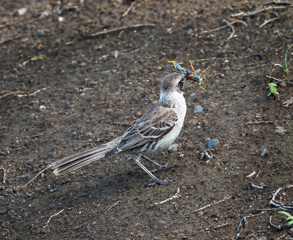
Galapagos Mocking Bird

(Techniical Stuff: Nikon D810 handheld with 70-200mm f/2.8 lens extended to 200mm; exposure 1/250th sec. @ f/8, ISO 800; very tight crop of final image)

The smaller birds, such as the Galapagos mocking bird, were more timid than most of the island wildlife but they still provided photo opportunities on occasion.  Interestingly, there are seven subspecies of the Galapagos mockingbird, and each one seems to be largely endemic to different islands of the archipelago.  Apparently, it was the differences (such as beak size and shape) among these birds, as well as his better known study of the Galapagos finches (15 subspecies) that sparked Darwin’s thinking about adaptive evolution.


Galapagos 24 Floreana IslandSunrise, Floreana Island


Coming Next: The World Famous Blue-Footed Booby

Galapagos Islands (Part 1)

Galapagos 21 Another Sunrise           
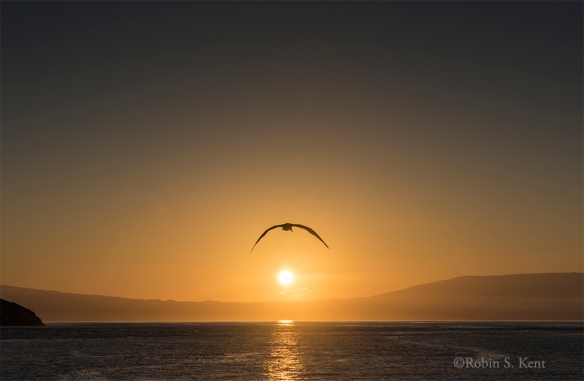
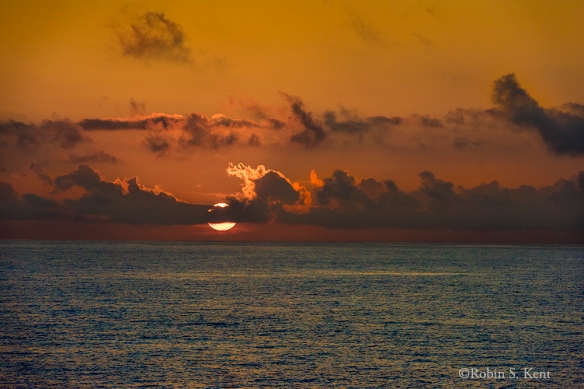
Sunrise on the Equator, Pacific Ocean

The Galapagos Islands are a chain, or archipelago, formed by volcanic action over the past 5 million years.  Located on the equator about 600 miles west of Ecuador. But what makes them special is the unique array of wildlife that is found there.  Many of the species are found nowhere else on earth and, because they lack natural predators, most have no fear of the thousands of tourists (even photographers) who come to see them every year.

Galapagos 02 Land Iguana

Galapagos Land Iguana, Feeding on Succulents

The Galapagos Land Iguana is primarily an herbivore, feeding mostly on cacti and other succulents and thus can go for long periods without drinking water.  This species can weigh up to 13 pounds and they can live for as long as 50 to 60 years. The female lays up to 20 eggs in burrows they have excavated.

Galapagos 07 Frigate Red Chest


There are two kinds of frigatebirds on the islands, but the males of both variants possess the distinctive red throat pouch which inflates into enormous heart-shaped balloons. It can take up to 30 minutes for the pouch to completely fill as the male hopes to enthrall a passing  female.

Galapagos 03 Frigate Bird with Nest Material
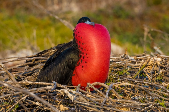
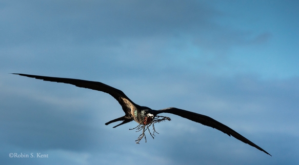
Frigatebird Carrying Nesting Material


Nesting occurs in colonies that may include members of both variants.  The nests are constructed mostly by the female with materials brought in by the male.  The birds can have wing spans of 7 feet.

CGalapagos 04 Frigate Chick
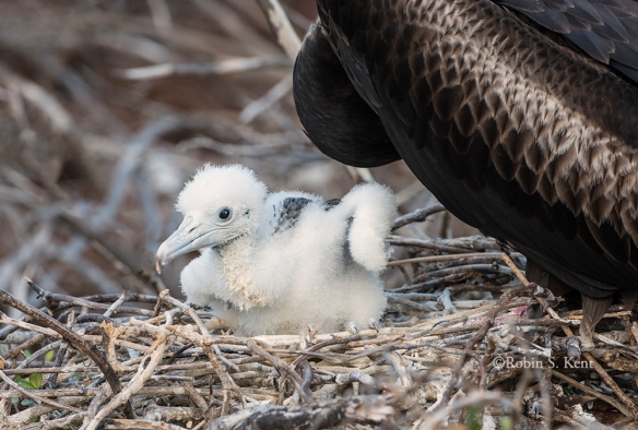
Young Frigatebird Chick on Nest

The female lays only one egg and it may take 40-50 days to hatch.  Both parents share in the nesting and feeding after hatching.  It will take another 20-24 weeks before the juvenile fledges but they continue to be fed for another 20 weeks or more before they fend for themselves.   Because of the length of this cycle, the female can reproduce only once a year at the most.

Galapagos 27 Comorant

Galapagos Flightless Cormorant Drying “Wings”

The Flightless Cormorant is unique to the Galapagos and is found on only two of the islands.  Only 1,000 breeding pairs exist.  Having no land-based predators, natural selection favored those birds that were better built for swimming and diving.  Their wings are about 1/3rd the size needed to fly.

Galapagos 17 Comorant
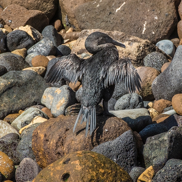
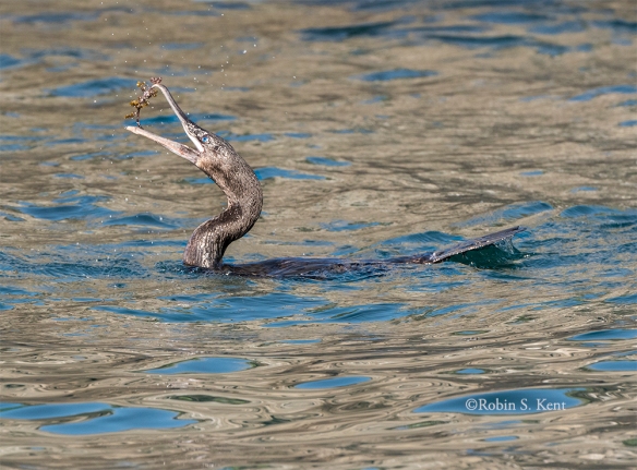
Flightless Cormorant with a Catch

Their courtship is unusual because it is the female that aggressively seeks out the male, and subsequently will depart her partner and offspring to re-mate serially with different males while males raise the young by themselves.

Galapagos 08 CrabSally Lightfoot Crab (Yes, really!)

Winner of my award for the creature with the best name (barely edging out the blue footed booby), the colorful  Sally Lightfoot Crab is a common sight in the Galapagos Islands.  According to one source, this little beastie is named after a famous Caribbean dancer because of its incredible agility.  I don’t know about the namesake, but these guys are quick.

Galapagos 01 Surf
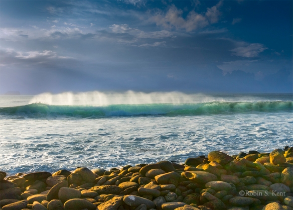
Wave Breaking in Late Afternoon Light


Next:  Galapagos Islands (Part 2)


Hidden Gems:  Hartford’s Sculpture Walk at Riverfront

Tomorrow’s meeting wasn’t going to start until 9:30 AM and the hotel was a 2-minute walk from the Connecticut River.  A quick check of The Photographer’s Ephemeris app revealed there would be an opportunity for a sunrise illumination (at 7:05 AM) of the Hartford skyline across the river.  OK, set the alarm for 6:15 AM.

Arriving at the river’s edge the next mornioing about 20 minutes before sunrise, I had a few minutes to check things out and noticed a stairway leading up to Founders Bridge. At the top of the stairs,there was a magnificent pedestrian walkway, wide enough for a car and way better than anything we have in Washington.

Hartford D-15-12-04-0228

Founders Bridge, Hartford Connecticut

And it turned out this was no ordinary promenade.  It was part of the Lincoln Sculpture Walk that follows a course through two riverside parks, one on each side of the river.  Made possible by a $500,000 donation from the Lincoln Financial Group, a local firm, it features 15 permanent sculptures dedicated to the life and times of Abraham Lincoln. Those who know my photography know that the Lincoln Memorial is one of my favorite subjects.

Hartford D-15-12-04-0224

“Emancipation,” by Preston Jackson

This sculpture, “Emancipation,” was fortuitously (for me) placed right a few steps from the stairway landing.  It is one of two works in the Sculpture Walk by Preston Jackson, a prominent African American artist from the Art Institute of Chicago.  It depicts a female slave carrying her infant and a few possessions toward freedom.  The soft illumination of the twilight minutes before the sunrise seemed to underscore the power of the work.

As the sun edged above the horizon, the colors began to illuminate the city’s skyline.  The image below was captured one minute after sunrise.

Hartford D-15-12-04-0238

Sunrise View of Hartford from Founders Bridge

But I could see that there were might be more potential down below along the river’s edge and I retreated down the stairway and found a good spot to wait. My luck continued as a series of clouds continued moving in from the west and the light breeze began to subside.  And sure enough, about 15 minutes later, the golden light reached its peak.

Hartford D-15-12-04-0266_68-RAW Pano

As I walked back to the hotel, it seemed that going out for a morning walk was a lot better than sleeping in.


Keep Shooting…..


AfterBefore Friday Week 55

Today marks Week 55 in the AfterBefore Friday series managed by Stacy Fischer of Visual Venturing.  It’s open to anyone and participants share their approach of transforming one of their own images into its final form, an expression of their creative vision.  You can find links to all of the other participants here.

I thought this would be a good opportunity to try out one of the new tools that appeared in the most recent Photoshop CC upgrade.  Most writers have been rhapsodizing about the new “Dehaze” tool, but I have been far more pleased by the integration of the Photomerge capability into the Adobe Raw Camera (Version 9.1) process.

Robin Kent ABFriday Week 55 Before

Original Image (one of four)

The above image is one of four used to produce an overall image the front of the Jefferson Memorial at sunrise.  Longtime readers may recall that I used a single image from this set in ABFriday Week 44.  But that was to produce a much tighter crop. This week it will be a wider view to include the tree on the left side of the building and some balance on the other side.  Now, I could have captured all of this in a single image using a wide angle lens, but I wanted to avoid the distortion of an extreme wide angle and I also wanted to be able to make really big prints if the image turned out nicely. (Technical: Four images with a Nikon D800E; 24-70mm f/2.8 lens at 42mm; Exposure: 1/160th sec. @ f/16, ISO 400)

Robin Kent ABFriday Week 55 Screen 01

The Well-Hidden Photomerge Button

The screen capture above shows the Adobe Camera Raw (ACR) display window with the  four RAW images opened as the first step for a photomerge.  In what must be one of the most obscure placements of a functional command in history, Adobe has seen fit to place this teeny little button in the upper left corner of the window, just to the right of the word “Fimstrip”  (Red Arrow).  If you select 2 or more images and then click on that little spot, you get the flyout menu (Yellow Arrow) that is displayed showing several options including “Merge to Panorama.”

Robin Kent ABFriday Week 55 Screen 04

Preview of Photomerge Process

If you click on that command, a preview window quickly appears as shown in the screen capture above. The ACR process has chosen which of three “projections”  it believes will produce the best result which, in this case, was “Perspective”  (Red Arrow). If you are not happy with that one, you can click on one of the other two to compare the results. It also provides a preview of an “Auto Crop” (Yellow Arrow) which essentially cleans up the ragged edges of a typical photomerge process.  A very nice touch, I thought. The image below shows the result when this box is unchecked.

Robin Kent ABFriday Week 55 Screen 03

Auto Crop Unchecked.

In some cases, one may decide to handle the cropping on their own, but it obviously did a fine job here.  Once you are happy with the result,  click on the “Merge” command and it quickly goes to the “Save As” function as shown in the screen capture below.  Just give the file the approapriate name and select the folder in which it is to be saved.  So far about 60 seconds have passed.

Robin Kent ABFriday Week 55 Screen 06

Saving the Merged image

As shown the Screen Capture below, a new thumbnail of the photomerge has appeared in the filmstrip (Red Arrow) and is ready to be processed like any other RAW file.

Robin Kent ABFriday Week 55 Screen 05

ACR Window after Save Command is Executed

From here one just uses their standard workflow.  In this case I used the follwing settings: Highlights decreased to -31; Shadows increased to +73; Whites increased to +57; Blacks increased to +16; Clarity increased to +30; and Vibrance increased to +39.  The image was then opened in Photoshop, where I spent some time removing a few of the people on the steps.  The final result is shown below.

Robin Kent ABFriday Week 55 After

Final Image

Comments and Questions are welcome.  Please be sure to check out the other examples of post-processing techniques at Stacy’s post, ABFriday Week 55.

Keep Shooting…….


Cherry Blossoms–Not Yet!

Although the cherry blossoms have yet to  fully awaken, there are plenty of other photographic opportunities right now in Washington, DC.

At sunrise two days ago, the tidal basin was almost completely deserted.   The sky was clear which means you can get the shot below as the sun clears the horizon.

Jefferson Sunrise 02

Sunrise, April 2, 2015

At sunrise the  next day, rain clouds were coming in from the west but there were some openings in the eastern sky.  Again, the tidal basin was deserted.

Jefferson Sunrise

Sunrise, April 3, 2015

The rain started within an hour after the image above was taken but it was a light rain so I checked out the status of the pink magnolia trees in Rawlins Park (E Street, Foggy Bottom) that usually are open before the cherry blossoms.

Tulip Trees 01

Afternoon Rain Shower, Rawlins Park

Tulip Trees 02

Magnolia, Rawlins Square

Tulip Trees 03

Magnolia, Rawlins Square

While photographing the square, I noticed some white magnolias across the street at the Red Cross National Headquarters (20th and E Streets NW).  A quick check showed that an evening shot might be worthwhile.

Red Cross 01

Evening, Red Cross Headquarters

This morning, I checked out the Enid Haupt Garden at the Smithsonian Castle on Independence Avenue.

Tulip Trees 05

Morning, April 4, 2015

If you want to photograph these trees, don’t delay.  They go quickly and inclement weather is forecast for mid-week.You can also find them in the Sculpture Garden (National Gallery of Art) and at the George Mason Memorial near the Jefferson Memorial.

Scouting Report: Getting Ready for Spring

The signs are unmistakable: the calendar says March, sunrise is coming earlier each day, the temperatures are rising, and the snow is disappearing.

Jefferson at Sunrise

Jefferson Memorial at Sunrise, March 12, 2012

After all, it’s been 3 years since I got a decent image on March 12th.  So yesterday afternoon (March 12th), I made a scouting run into the city to check out a few sites for possible photo opportunities.  As I made the rounds, it appeared that conditions were promising for a sunset image (see below) so I kept my eye on the clouds building up as I explored the area around the National Mall.

The scouting findings may be of interest to photographers in the Washington, DC area, others can skip to the end and see what happened at 7:25 PM.

Solar Cycle:  For the next few days, the late afternoon sun (when skies are clear) will be providing some opportunities as it illuminates the Federal Triangle Buildings along the north side of Constitution Avenue and the recently renovated Arts and Industries Building on Independence Avenue.

Fountains:  As usual at this time of year, virtually all of the fountains are still shut down for the winter.  This includes the fountains and pool at the World War II Memorial and the Reflecting Pool between the WW II Memorial and the Lincoln Memorial.  In addition, the waterfall at the northwest corner of the Museum of the American Indian is dry and the waterfalls at the FDR Memorial are also turned off.

The Tidal Basin:  There is a significant amount of ice still in the Basin, but this should be melted in a few days.

National Gallery, East Wing: The large construction crane is finally gone, although there is still a considerable amount of fencing and construction equipment on the south and east sides of the building.  However, there are good angles on the west side of the building.

Ongoing Construction:  The US Capitol is still under scaffolding, of course, and the white plastic wrap covering part of the scaffolding has been altered for the worse (who would have thought that was possible) by adding a section with a tawdry taupe color.  The new African American Museum is still far from completion and news reports state that the opening date has been pushed back to early 2017.  There is better news a few blocks to the west where the interminable construction project for a relatively small flood control wall (17th Street and Constitution Avenue) is all but wrapped up.  The unsightly wooden fence on the northeast corner of 17th and Constitution is gone, leaving a rather graceful stone wall curving toward the Washington Monument.  Across 17th, the construction equipment has been removed and the landscaping seems completed.  However, there are still some chain link fences protecting the larger trees along 17th Street.

Upcoming Events

March 14: DC Rock ‘n Roll MarathonThe Start Time 7:30 AM likely will complicate efforts to photograph anything else so plan accordingly.  Details here.

March 20: The Equinox.  Check your Photographer’s Ephemeris app for an opportunity near you.

March 28: Kite Festival, the long-running kite festival will be in its usual location on the grounds of the Washington Monument starting at 10:00 AM.  For details, click here.

April 4: Full Moon. Check your Photographer’s Ephemeris app for an opportunity near you.

Kite Festival 02

Kite Festival

Kite Festival 03

Kite Festival

Sunset at the FDR Memorial

As the sun edged closer to the horizon last night, I made my way over to the Franklin D. Roosevelt Memorial which is located on the west side of the Tidal Basin.  DC locals might think this is a strange location to capture a sunset, but I thought it would be a good backdrop for a specific feature at the Memorial.  The result is shown below.

Roosevelt Memorial

FDR Memorial at Sunset, March 12, 2015

(Technical Data: Nikon D800E with 24-70mm f/2.8 lens on tripod, extended to 24mm; exposure 1 sec. @f/16, EV = -1.0 ISO 400.)

The Memorial, on 7.5 acres chronicles the four terms of Roosevelt’s Presidency.  This section, with the five pillars and five panels on the wall, were intended to represent the social programs (New Deal) during his presidency. The design has been criticized as the “least successful” of the many sculptures in the Memorial, and I would agree that their intended symbolism is opaque.  Nevertheless, I have found them to be an interesting photographic subject.

Coming Soon–Iguazu Falls (Really!)

Journey to Antarctica – Part 4

First, a quick update on the Herndon ArtSpace Fine Art Photography Competition.  I was quite pleased on Saturday evening to receive a 3rd Place Award for my “Clearing Storm, Yosemite Valley” image (see my previous post here).  Maybe I should do this more often…or should I quit while I’m ahead?   Anyway, back to the saga of the White Continent……….

Antartica Map 03 Version 2

It seems that every Antarctica trip veteran we met before our departure had a different story about the weather.  Although we’ve been there only once, it’s pretty easy to see why.  Even when conditions are not extreme (i.e., enormous waves, huge storms), the weather is still volatile and often localized. This combination can make things very interesting. The following sequence of images on our passage through the Lemaire Channel is just one example.

Antarctica 19

Lemaire Channel, Looking South at Sunrise

Antarctica 20

Lemaire Channel, Looking East  (One Minute Later)

Antarctica 21Lemaire Channel (25 Minutes Later)

Lemaire Channel is about 7 miles long and a mile wide at its narrowest point. Because of the closeness of the sheltering mountains, it can be as smooth as a lake.  Icebergs, however, can block the passage especially earlier in the season.   Our destination was Petermann Island, home to another colony of Gentoo penguins and no iceberg congestion interfered (two images below).

Antarctica 22

Gentoo Penguin Surveys His/Her Domain

Antarctica 23

Gentoo Penguins on Petermann Island

Petermann Island was the southernmost point of our expedition, even though we would not have complained had the captain decided to break ranks and continue on. But such was not the case and that evening we retraced our route through the Lemaire Channel. On the positive side, we were treated not only to some very nice evening light by the setting sun but also the spectacle of a rising full moon (images below)

Antarctica 24

Sunset, Antarctica

Antarctica 25Alpen Glow, Antarctica

Antarctica 26

Moonrise, Antarctica

Next—Paradise Bay and Beyond